
According to a recent study published by the AGU, a global community supporting Earth and space sciences, the number of wildfires in the Western United States has decreased significantly since 1992, while the total area burned has increased. In Washington, wildfire rates vary greatly from year to year. But for the most part, the largest, most damaging wildfires have increased over the last six years. The factors affecting the start and the spread of wildfires in the state remain very difficult to estimate.
The total number of acres burned in Washington rose sharply from 2001 to 2021, followed by multiple years of much lower-than-average burned acreage (in 2022, 2023, and 2025).

According to the AGU study of the western U.S between 1992 and 2020, the land area affected by wildfires increased by 4%. In 2020 alone, over nine million acres burned across the western states.
The Washington Department of Natural Resources (DNR) fights 900 wildfires annually, 70% of which are in Eastern Washington. From 2000 to 2020, 5.6 million acres in Washington state were burned by wildfire, with nearly 1.5 million acres burned in 2014 alone from the lightning-induced Carlton Complex fire in north-central Washington.
From Washington’s DNR tracking, the last 5.5 years have experienced 71 large wildfires (over 1,000 acres) compared to 56 in the previous six years. Mega wildfires (burning over 50,000 acres) increased to 12 during the last 5.5 years, compared to the seven mega wildfires in the previous six years.
Contributing Factors
Wildfire suppression laws and mandates led to overgrown land, contributing to the intensity of wildfires in the state, according to the Western Fire Chiefs Association. Motivated originally by white settlers’ fear of wildfire and later by threats to logging earnings, state and federal fire suppression laws in 1910 prevented Indigenous people from their traditional fire stewardship, criminalizing the practice.
For likely thousands of years before this, Indigenous people maintained forested areas with intentional burns to clear vegetation and promote the growth of edible and otherwise useful plants, while improving wildlife habitats and biodiversity. These land management practices decreased the amount of highly flammable underbrush and organic material that fuels wildfires today.
Additionally, the state attributes approximately 90% of wildfires to people – with half considered accidental and the other half determined to be with intent or by neglect. This includes discarded cigarettes, improperly extinguished campfires, fireworks, debris burns, and equipment malfunctions. This human-caused rate is roughly the same across the rest of the country.
Climate-change-related causes of wildfire cannot be ignored: decreasing snowmelt, heat waves, increased drought, and insect-related tree and plant weakness all have a detrimental effect on wildfire reduction. As Washington State’s Department of Ecology states, “if greenhouse gas emissions continue to rise, we can expect more wildfires, for longer seasons.”
Once a wildfire has begun, the conditions that determine the extent of surface area burned are fuel and its conditions – including moisture levels and density of the plant material; the weather conditions – including humidity and wind; and the topography of the land, which accelerates or hinders the spread of the fire.
Addressing the Problems
After over 100 years of experiencing the backlash from the criminalization of the long-held land stewardship practices by Indigenous communities, the DNR launched a prescribed fire program in 2021 to reduce wildfire risk in central and eastern Washington. Interested residents can sign up to receive notifications from DNR about upcoming subscribed burn events.
Washington state legislation in 2021 also allocated funds to upgrade the state’s ability to mitigate wildfire damage. Along with funds and services from a wide range of federal, state, county, and private agencies, efforts to prevent and extinguish wildfires are being addressed. Initial response teams in more recent years have been able to keep 95% of wildfires in the state below ten acres, according to the DNR.
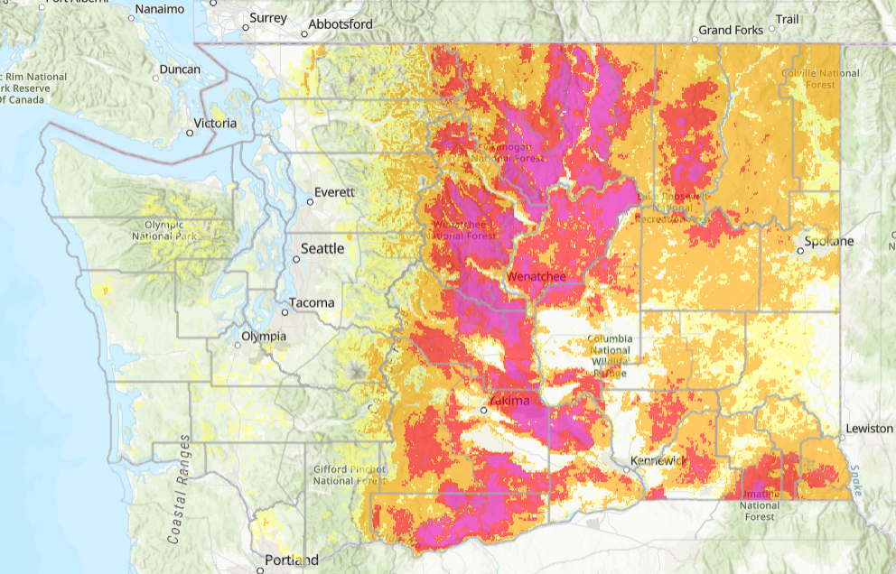
To enhance preparation and response in areas of the state with increased wildfire risk, Washington DNR developed the Wildfire Hazard and Risk Mapping Initiative. The map displays wildfire probabilities ranging from very low (under .05% occurance in 2000 years) to very high (over 2% occurrence in 50 years). The Hazard Map represents both the burn probability and the intensity of the fire according to predicted flame height. At this point, the map is considered in draft status.
Additionally, Washington residents can stay tuned into active wildfires via the commercial Frontline Wildfire tracker site and app.
Higher-risk area mitigation tactics
Creating a defensible space is the DNR’s top recommendation, in recognition that the spread of embers is responsible for igniting dwellings and other structures. According to the National Fire Protection Association, in addition to constructing or retrofitting homes and other structures with fire-resistive materials, property owners can reduce ember ignitions by reducing flammable vegetation, especially in the immediate and intermediate zones surrounding homes.
Additional tips for safety during a wildfire include maintaining contact with neighbors and ensuring that first responders can not only find but also access your property.
To reduce the number of wildfires caused by negligence, Washington residents should be aware of the risks involved with fireworks, campfires, debris fires, and improperly maintained equipment and vehicles. And most certainly, everyone should properly extinguish and discard cigarettes and other burning items.
More from the Evergreen Post Intelligencer
- Mill Creek is exploring various density options in its south town center
- With the 4th of July in view, Washington’s wildfire rates remain wildly unpredictable
- WSU’s research improves safety in the nuclear industry

- BABIP gods hate Josh Naylor

- The lessons we have refused to learn 122 years after the General Slocum burned on the East River

- USPS postmaster threatens to not mail out ballots if states don’t comply

Discover more from Evergreen Post Intelligencer
Subscribe to get the latest posts sent to your email.